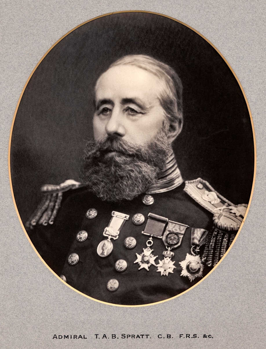
Crete: the island that tipped


spratt

Thomas Spratt

CAPTAIN THOMAS ABLE BRIMAGE SPRATT RN (you’ll know of him by now if you have been paying attention), in 1851, visited Crete for surveying purposes which involved an archaeological exploration of the island. One of his interesting discoveries was the way in which relative levels of land and sea had changed over the island in historic times.  Following a meeting with the geologist, Sir Charles Lyell, he wrote to him to clarify a point about the island’s movement:

“Dear Sir Charles, Fearing you may be impressed with the idea that the eastern end of Crete had gone down as much as the west. I am induced to write a line to rectify it, if so; and to state that movements in the eastern half of the island have neither been as great nor apparently as uniform as the western movement. Both are subsequent to the historic period and the evidences are in both instances indicated by the elevation or partial submergences of some ancient Greek building or city.”

The letter was written on the on the 28th of February 1856, which was a Thursday. The two must have met the previous evening because the following day Spratt wrote again to Lyell confirming the situation, perhaps as an afterthought:

“My dear Sir Charles, You understood me quite right on Wednesday evening in respect to the fact that the western half of Crete having been elevated, and the eastern half depressed or gone down a few feet.”

The submergence of the east coast can be seen today at the Minoan palace site of Kato Zakros – part of it is underwater even in mid-summer (pic below).

zakros

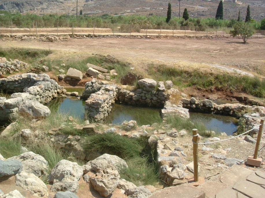
Kato Zakros (eastern Crete) flooded store rooms in July

However, the movements were not restricted just to the east and west tips of the island. Spratt observed that there was a maximum elevation of nearly 26 feet occurring on the south coast at the base of the White Mountains to the west of Sphakia, 17 feet to the extreme west of the island and declining to 6 or 7 feet along the north coast to Suda Bay.  He added that “all the ancient cities included in this line of coast have been affected by the elevation by the conversion of their ancient ports into dry land.”

At first, for some reason, he found this puzzling, not thinking until a little later, that the elevation must have “occurred subsequent to the existence of these cites” (all in the letter, Spratt to Lyell, letter, 29th February 1856)
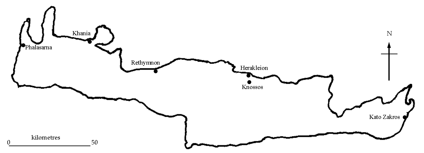
map crete

Crete

Spratt had discovered this movement when searching for evidence of the ancient port of Kutri at Phalasarna on the western end of Crete.  He noticed possible ancient activity, some distance from the sea and wrote to his friend (a seasoned traveller of the Greek mainland), William Leake:

“On going to Phalasarna I looked for its ancient port, mentioned by Scylax … but I could find no artificial work in the sea. There is however, a long ledge of rocks, or rather an islet which lies off it, helping to form a natural but not an artificial harbour. This satisfied me in part, till, on examining the ruins, I saw in the plain a square place enclosed by walls and towers, more massive and solid than those of the city … I was instantly impressed, for several, reasons, that here was the ancient port or artificial port, although full 200 yards from the sea and nearly 20 feet above it. My first idea was, that the ancients had a means of hauling their vessels into it as a dry dock; but at last the coast elevation was uncumbered(sic?) and on measuring the sea mark at its upper level here I found that the bed of this anc[ient] port is now 3 or 4 ft below that level.” (letter Spratt to Leake, letter, 18th September 1853).

Then Spratt recalled a visit to the island of Cerigotto (Antikythera) where he had noticed an elevation of coastland and it occurred to him that the same may have taken place on Crete. He then measured the sea-marks at Phalasarna which convinced him that it had – the new sea marks were three feet below the old marks (plan below). This justified his theory that the inland “quadrangular space enclosed by the unusually massive Hellenic [Hellenistic] walls upon the plain in front of the chapel of Aghios Giorgis” was, indeed, the port.

Picture1

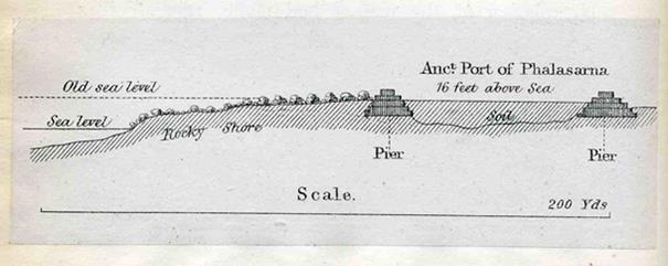
Spratt’s plan of the Phalasarna harbour with pre-5th century AD and 19th century AD sea levels

In his above letter to Leake, he originally dated this movement of the island to a date prior to history (that will be prior to Greek writing of 776 BC). but was unsure, suspecting a more recent date due to a possible change in the markings on the landscape – concluding with a period “subsequent therefore to the decline of the Roman Empire [5th century AD]”.  In his journal he dated it to the late Roman period. Indeed, the tectonic displacement has been dated to the 5th century AD.

phalas

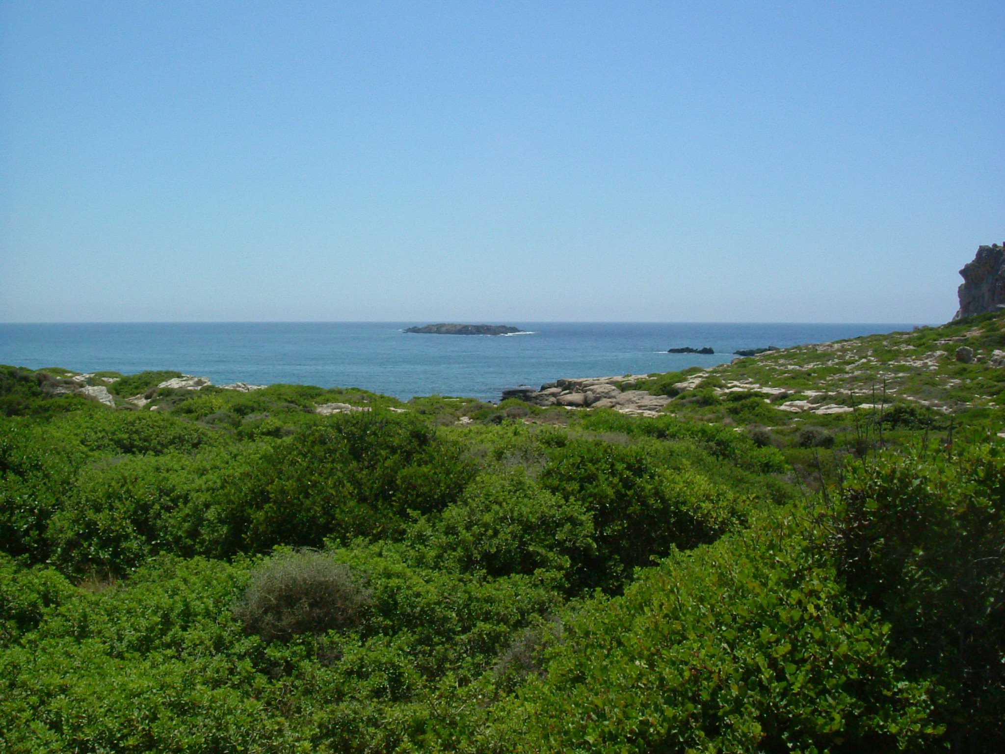
View to coast from the now ‘inland’ harbour at Phalasarna today

Crete being in an earthquake zone it is hardly surprising that it has moved about somewhat over the centuries, much to the initial confusion of earlier ‘investigators’ such as Spratt. But he was made of sterner stuff and was admirably able to resolve the inconsistencies before him.


Next week: Lets’s go to Mycenae


Artemus Smith’s Notebooks

I continue my research of the notebooks of Dr Artemus Smith, archaeologist of great courage, determination and fiction. Here is another extract:

Whilst travelling in Greece, I was invited to play cricket for the British School [of Archaeology] at Athens. My very good friend, Sir Mortimer Double-Dealer (a rival sportsman) needed to contact me and he telephoned the clubhouse where I was playing. He was told that I had just gone in to bat. “That’s all right,” he replied, ”I’ll hang on.”


AT


St Nicholas’ Church at Bramber Castle

st nich

St Nicholas’ Church, Bramber

EDWARD THE CONFESSOR (1042-1066) gave the parish of Bramber (and nearby Steyning) to the Abbey of Fecamp in Normandy. As seen in the first blog (if you have been paying attention), when William the Conqueror took his place as King of England he granted the ‘Rape’ of Bramber to William de Braose but the monks of Fecamp still claimed rights to the land (see ‘Historical Note’ below). In 1073, de Braose, in competition with the Abbey of Fecamp,  built the church of St Nicholas, just outside his castle’s gatehouse, for Beneditine monks of the Abbey of St Florence (Florent) at Sanmur in Anjou.  In 1080, those monks moved from St Nicholas and established themselves at the Priory of Sele in Beeding (village next door) but St Nicholas remained as a religious centre for the occupants of Bramber.

Historical Note (not that the rest of this is not historical you understand): After Edward the Confessor died, new king, Harold, decided to cut Fecamp’s ties with St Cuthman in Steyning (along the road from Bramber – pay attention). William of Normandy (he hadn’t been upgraded to ‘Conquerer’ yet) was furious and planned retribution.  And so Steyning maybe accountable for the cause of the Norman Conquest ……….

King2

Anyway, in 1085, William le Conq belatedly re-confirmed Fecamp Abbey’s claim to St Cuthman Church (now St Andrew’s in Steyning). This was not a good thing as it was to lead to various disputes between the Abbey’s monks at St Cuthman  and Billy de Braose (we’ll call him Will de B). In fact, 3 court cases came to pass in 1086. The first involved the monks successfully stopping Will de B charging a 2d toll at Bramber bridge for boats to pass through to the Steyning port. In the second case, Will de B was ordered to fill in ditches he had dug to allow water from a tributary of the River Adur to flood the east side of the moat of his castle and to make it easier for water transportation to the castle. In both cases the monks of St Cuthman claimed they had the rights to the river – and the court obviously agreed. In the third case, the monks considered they had the rights to bury the Bramber dead at St Cuthman – and receive the burial fees. Again they were successful and burials at St Nicholas had to be dug up and reinterred at St Cuthman – along with payment of the burial fees. Monks with a mission!

conj map2

Conjectural map of 12th century Bramber/Steyning (yellow circle is St Cuthman, white circle is Bramber Castle [ditches from tributary NE & SE], red circle is Bramber bridge)

st nic plan 2

Plan of St Nicholas over the years

See the above plan of St Nicholas over the years. The north and south transepts have disappeared entirely and the east apse was replaced with a chancel (in or around 1250), which has also since disappeared (after the civil war in the 17th century).  Arches of all three are still visible on the outside walls.  The single aisle and tower are original structures (well, the tower has needed some repairs – see pic below).

st nics 1770

St Nicholas c 1770 – towerless

In 1459, the Priory link with monks was dissolved and the church (& Priory at Sele) was granted to St Mary Magdalen College, Oxford, by Henry VI (at bequest of William of Waynflete, Bishop of Winchester).  It had now obtained full status as a parish church.

As a result of the dissolution of monasteries in 1538 the church became  the property of the Crown, who granted it to Richard Andrews and Nicholas Temple, who sold it to Owen and Clement Oglethorpe, who re-granted it back to Magdalen College in 1546, where it remained until 1952.  It then passed to the Bishop of Chichester, who holds it today.

 st nic 19th c

St Nicholas in the 19th century

The church was damaged during Civil War (c1643) and it took many years for it to be fully repaired.  The materials from the wrecked chancel were utilised to repair the tower.  In 1931, the vestry was added to west side of the church.

Inside the church is a fine arch with two original Medieval carvings on its capitals. The left column said to be one of only three examples of Norman 11th century figured sculpture in the country. The right column carving is most likely 14th century and has a Maltese cross which associates the church with the Knights Templars who occupied the village around that time (see pictures on link below).

As is rather obvious, the church has fared somewhat better than the castle (see previous blog if you don’t believe me) and is still in use today.

Click here for another link to a site regarding the church.

Next: Ghosts of Bramber Castle …….. and another extract from Artemus Smith’s notebooks (talking of which …..)


Artemus Smith’s Notebooks

I continue my research of the notebooks of Dr Artemus Smith, archaeologist of great courage, determination and fiction (see last blog). Here is another extract:

I had been working on a survey of a churchyard in Vienna.  On the first day I could hear music which was emitting from the gravestone of none other than Ludwig van Beethoven.  Being familiar with his work, I soon realized was that it was his Ninth Symphony, but it was playing backwards!  After luncheon, I returned to hear his Seventh Symphony, again, playing backwards.  Curious as I was, I sought the graveyard’s caretaker.  On our return to the headstone, the Fifth Symphony was playing, as I expected, backwards.  I asked the caretaker whether he could provide a suitable explanation. 

“Nothing to worry about” he said, “He’s just decomposing.’’

AT


Artemus Smith

Whilst on the subject of Bramber and archaeology, but just as an aside, I would like you to meet Artemus Smith – and my apologies to any USAS members reading this – I’m just introducing him to the others!

AS THE TALE GOES, a few years ago the, then, vicar of St Nicholas Church in Bramber had been clearing out a dust laden cupboard in the vestry of the church. There he came across an old tin box containing various documents of an archaeological nature. He thought I might like to look through them. Amongst the miscellaneous papers were notebooks of a certain Artemus Smith. I decided to research him.

box

DR ‘ARTEMUS’ SMITH was an archaeologist of great courage, determination and fiction.  He was born Ambrose William Dermot Smith in 1901, the only son of Brigadier Sir Hartley Archibald Jefferson Smith and Lady Constance Louise Smith (nee Carter-Bazeley). He reluctantly studied the Classics at school and is remembered for his frustration with the ancient languages, “It’s all Greek to me” he had said (this may have been where the expression first came from – or not).

 AT

Artemus Smith

He went up to Oxford to study Law but spent most of his time hunting, shooting and fishing. It was as a result of this that he picked up from his colleagues his nickname ‘Artemus’ (male version of Artemis, Goddess of hunting in case you were wondering) and the name has remained with him. Despite these activities he successfully completed his degree but on coming down from Oxford he took a break before professional study and travelled Europe with his cousin, Horatio Smith (see below). It was during these travels that he first became involved with archaeology but was put off it as a career due to the derisory pay (nothing changes). After various trips with his cousin and various ‘dallying’ in archaeology both abroad and in England, he qualified as a barrister and was Called to the Bar to practise law (not to be confused with being called to the public bar to practise drinking – although it is rumoured he did that as well).

barrister

This career (the Bar, not drinking) was interrupted by the Second World War and he volunteered to join the Royal Air Force and was soon to be piloting a Wellington bomber. His service was cut short after he flew into a German spotter plane over Germany (“well, strap me, it was dark and I didn’t see him,” he had said, adding, “and anyway, who was supposed to be doing the spotting?”[1]). He ended up in a German prisoner of war camp, Stalag Luft III (better known for ‘The Great Escape’ – in fact, it has been suggested that the character played by Steve McQueen in the film was based on Artemus Smith[2]).

 Picture1

Believed to be Flight Lieutenant ‘Artemus’ Smith at Stalag Luft III (drawing by Henri Picard – sadly one of the 50 shot after ‘The Great Escape’)

His experience as a prisoner of war – digging – gave him a more intent interest in archaeology. After the war, he abandoned the legal profession and went up to Oxford again but this time to study Archaeology (he was now a man of substantial inherited means after the death of his father so ‘derisory pay’ was no longer an issue). He went on to obtain his doctorate and then spent some time supervising and thereafter quelling disruptive and rebellious excavators on the ancient site of Arcadia in Greece – obtaining another nickname, ‘Smith of Arcadia’ [3].

His cousin, Professor Horatio Smith, was an archaeologist and lecturer at Cambridge University and gave Artemus much encouragement in the field. An account of Horatio’s heroic and equally fictitious activities is reflected in the excellent 1941 film Pimpernel” Smith  (click on name for film) wherein Horatio (played admirably by Leslie Howard) helps victims of nazi persecution escape from Germany during the build up to WWII. A ripping yarn highly recommended.

b29a3e8d-4e98-4521-ada0-143ca92248c9

Prof. Horatio ‘Pimpernel’ Smith

When Artemus asked Horatio about working in archaeology, the latter replied, “Well, an archaeologist is a person whose career is in ruins.” He added, “Such a person may be relied upon to make wise, intelligent and coherent analysis – having exhausted all other alternatives”[4].

Interestingly enough, Dr Henry Walton Jones Jnr (better known as ‘Indiana’ Jones) would have been a contemporary of Artemus Smith (certainly copying Smith’s flair). It is, therefore, somewhat surprising that I have not found any mention of Jones in Artemus Smith’s notebooks. I’m sure, because of their similarities, the two would have met up or, at least, been in communication. This makes me query the actual existence of Indiana Jones or whether he is just the figment of someone’s  extravagant imagination (oh me of little faith).

The rest, as they say, is history – well the notebooks at least (see below) – other than to add that Artemus sadly died in 1988, at the age of 87, from a fall from his motorbike whilst dirt-track racing on the Sussex Downs.


Footnotes

[1] Letter to his cousin Horatio Smith

[2] Letter from Sir Dandelion (now Lord) Attenboot to Artemus Smith saying that he knew someone who knew someone else  who had heard this – so it must be true  (Attenboot added, “they got some young American fellow to play the part to disguise the fact that the character was a Brit”)

[3] Sometimes confused with some chap called Lawrence

[4] From his unpublished autobiography entitled: Wot ho! Dig it all up


Artemus Smith’s Notebooks

Anyway, if you believe all that then you’ll believe this: as I have been perusing Artemus Smith’s archaeological notebooks, I will bring you extracts from them on each blog hereafter. Here is the first one:

I have just returned from a camping excavation of the city of Troy, with my very agreeable companion, Barratt Holmes, a relative of the famous Sherlock Holmes.  Barratt, too, is a detective of some fame and with similar deductive powers conducive to archaeology.  On the first night we camped outside the romantic ruins and having fortified ourselves with fine wine, we retired to our tent.  Some hours later, I awoke and nudging my colleague, enquired, “Barratt, my dear friend, look up and tell me what you see.”

Barratt replied, “I see hundreds of stars.”

“What do you deduce from that?” I asked.

Barratt thought for a minute, then responded, “Astronomically, I deduce that there are millions of galaxies and potentially billions of planets.  Astrologically, I deduce Saturn is in Leo.  Horologically, I deduce that the time is three o’clock.  Theologically, I deduce that God is all-powerful and we are but small and insignificant.  Metrologically. I deduce we will have a beautiful day tomorrow.  Why, my good friend, what do YOU deduce?”

“My dear boy,” I replied, “I deduce that some bounder has stolen our tent.”


Next blog (next Friday): St Nicholas’ Church at Bramber Castle – and another extract from Artemus Smith’s notebooks